#201 - 5760 Teredo St
Sechelt, BC V0N 3A0
Canada
Sechelt, BC V0N 3A0
Canada
|
#201 - 5760 Teredo St
Sechelt, BC V0N 3A0 Canada |
|
|
Capt. George Henry Richards: 1860 Sunshine Coast Survey
SECHELT, BC — APRIL 21, 2009 — Local real estate agent Gary Little has written the following article relating to Captain George Henry Richards and his important 1860 survey of the Sunshine Coast. This article appeared in edited form in the September 2010 issue of Harbour Spiel.
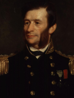
Capt. George Henry Richards (1865) (National Portrait Gallery) Richards was born on January 13, 1820 in Antony, Cornwall, England and entered the navy as a young boy in 1832. He began to develop surveying skills from the very start of his career. From 1835 to 1840, as midshipman of the Sulphur, he helped survey portions of the west coasts of North and South America, some Pacific islands, New Guinea, and the Moluccas. In 1842 he was assigned to the navy's survey of the Falkland Islands, then, from 1848 to 1852, to the survey of the New Zealand coasts. From 1852 to 1854 he participated in the ongoing search for lost Arctic explorer Sir John Franklin and distinguished himself by leading several sledging expeditions covering over 2,000 miles while mapping unknown coasts in the vicinity of Northumberland Sound. In 1854 Richards was promoted to the rank of Captain and his first commission brought him to the west coast of North America aboard the surveying ship H.M.S. Plumper, a 21-gun screw sloop. He reached the colony of Vancouver Island on November 9, 1857 following an 8-month westward voyage from England via the Straits of Magellan.
Richards had been named the Second British Commissioner for the San Juan Islands Boundary Commission and his mission was to conduct surveys to help resolve the boundary dispute with the United States relating to the path of the international border through the San Juan and Gulf islands between the mainland and Juan de Fuca Strait. The other British commissioner was Capt. James Charles Prevost of the H.M.S. Satellite. (Britain eventually lost this dispute: in 1872 arbitrator Kaiser Wilhelm of Germany established the current international boundary through Haro Strait, making the San Juan archipelago American territory.)

H.M.S. Plumper at Port Harvey, Vancouver Island (1862 engraving; from a drawing by E.P. Bedwell) (From the Gary Little collection)
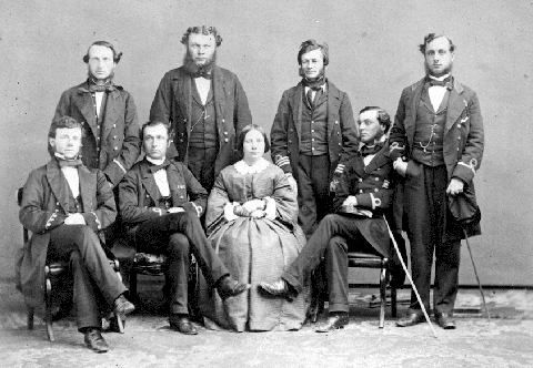
Mrs. Mary Richards and the officers of H.M.S. Plumper (December 1860) Standing: Dr. David Lyall, Paymaster W.H.J. Brown, Capt. G.H. Richards, Master Daniel Pender Seated: Master E.P. Bedwell, Lieut. R.C. Mayne, Mrs. Mary Richards, Lieut. William Moriarity (Image B-03617 courtesy of Royal BC Museum, BC Archives)
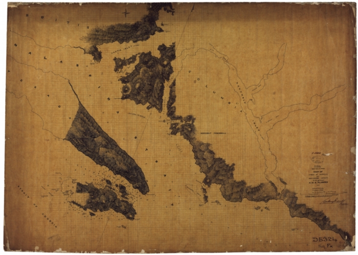
Sunshine Coast Chart (1860 manuscript) (United Kingdom Hydrographic Office) 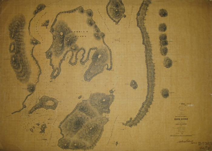
Howe Sound Chart Featuring Bowen, Gambier, and Keats Islands (1860 manuscript) (United Kingdom Hydrographic Office)

Sechelt Inlet Chart (1860 manuscript) (United Kingdom Hydrographic Office) His three primary naming themes were the Battle of The Glorious First of June in 1794 (in Howe Sound), horse racing (in Welcome Pass), and the Battle of Cape St. Vincent in 1797 (in Jervis Inlet). The names Howe Sound and Jervis Inlet themselves came from George Vancouver. See The Romance of Historic Names by S.C. Heal (Cordillera Books, 2006) for a concise summary of the stories behind many of the names used in these areas.
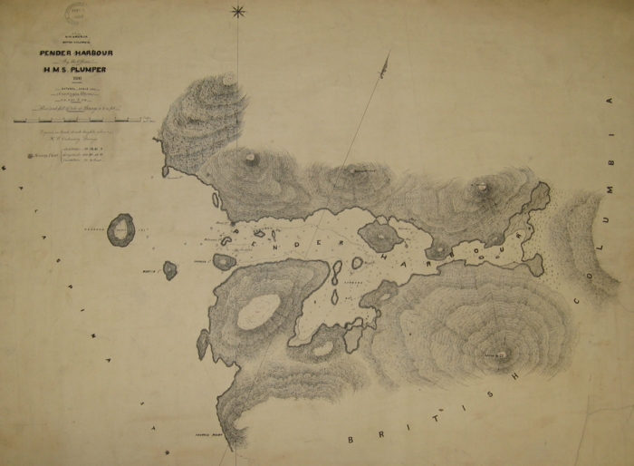
Large-Scale Chart of Pender Harbour (1860 manuscript) (United Kingdom Hydrographic Office)
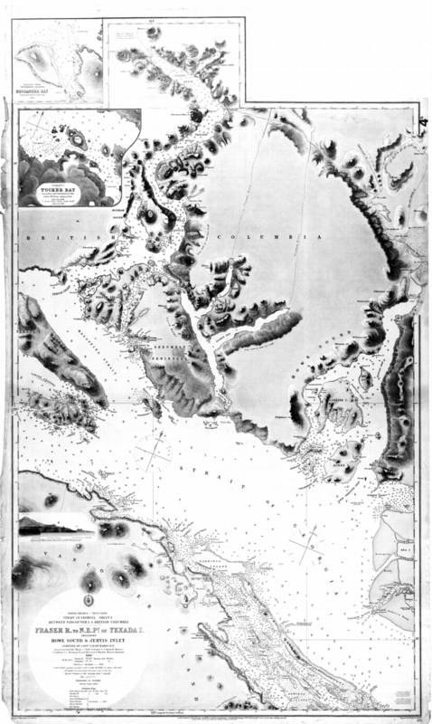
Printed Chart of Fraser R., to N.E. Pt. of Texada I. (1863 edition) (Image CM_C2308 courtesy of Royal BC Museum, BC Archives) Richards surveyed British Columbia and Vancouver Island coastlines until December 1862 when he sailed home to England in the H.M.S. Hecate having spent five years in the colonies. (His surveying duties were assumed by Daniel Pender who continued charting the area in the S.S. Beaver until 1870.) He then served as Hydrographer of the Navy from 1864 until his retirement from the service in 1874. For 20 years afterwards he was first the Managing Director, then the Chairman of the Telegraph Construction and Maintenance Company (Telcon) where he was able to advance global telegraphic communication by laying 76,000 miles of submarine cables. During this period of his life he was knighted (1877) and promoted to the rank of Admiral (1884). Admiral Sir George Henry Richards, K.C.B., F.R.S. passed away in Bath, England on November 14, 1896 at the age of 76. His Royal Society obituary observed that He was a man of great ability, of sound common-sense, and of untiring activity, and his unfailing good humour, general shrewdness, and kindness to younger members of his profession caused him to be universally beloved and respected. Local fame seems to have eluded Richards. Although he generously named dozens of landmarks after his officers, his peers, his ship, and even a favourite racehorse (Thormanby, winner of the 1860 Epsom Derby), the only coastal feature today in British Columbia that has been named after him (and this did not happen until 1948) is the nondescript Richards Channel off the northeast coast of Vancouver Island. (Richards Street in downtown Vancouver was named after Lt. Gov. Albert Norton Richards. Another Richards Street in Vancouver was named after Capt. Richards but the street was renamed Balaclava in 1907.) Perhaps this oversight can be rectified as we near the 150th anniversary of his Sunshine Coast survey so that we finally properly recognize Capt. Richards for his important contributions to the early economic development of British Columbia. Further Reading
— * —
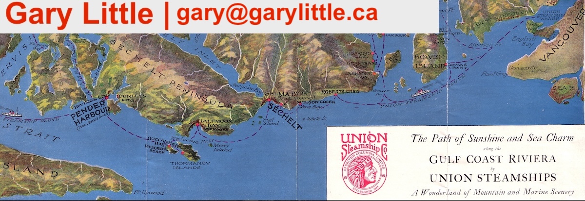
Gary Little is a realtor® and licensed real estate trading services representative in the offices of Royal LePage Sussex in Sechelt, British Columbia, Canada. He is a former senior software marketing manager, having previously worked in Silicon Valley for almost 20 years at the worldwide headquarters of Apple Inc. and Sun Microsystems, Inc. He is well known for his interactive real estate map of the Sunshine Coast (map.garylittle.ca).
— 30 —
CONTACT INFORMATION
Gary Little, realtor® This news release is located online at: http://www.GaryLittle.ca/maps-historic/richards.html |